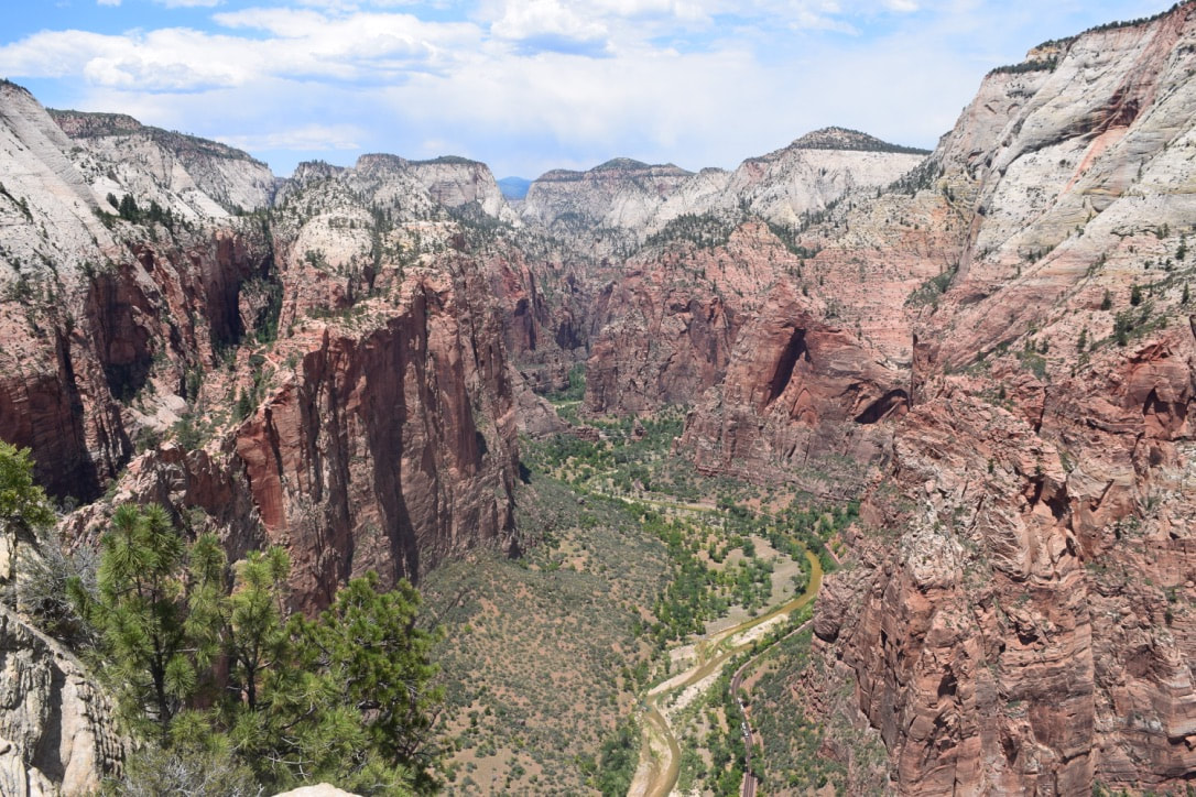
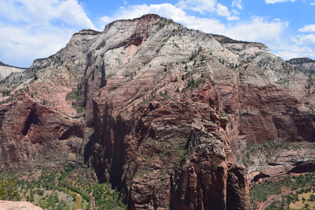
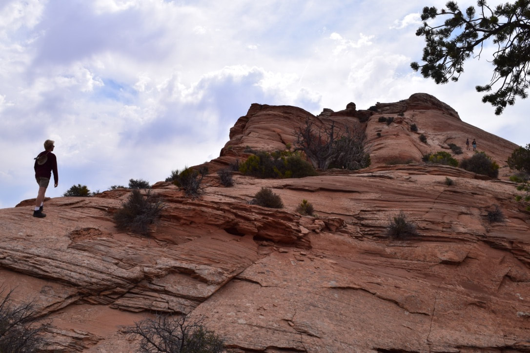
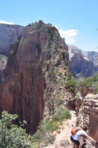
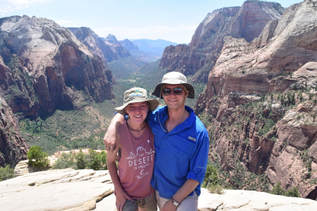
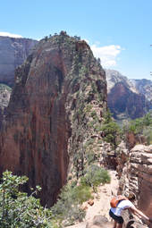
 The day we hiked to Angel’s Landing started with us sleeping in for three extra hours at the Zion River Resort after hiking The Narrows the day before. It didn’t matter that we started our hike at noon in the peak of the 100 degree heat (even though we don't recommend it). Tthe view that awaited us at the top was worth every bead of sweat and more. The first two miles of the West Rim Trial are uphill, concrete switchbacks. This trail is not as much fun as the actual Angel’s Landing trail, but it does include a few shady stopping points. On the other hand, the sand and rocks of Angel’s Landing trail were cooler than the concrete path. Climbing Angel’s Landing was less intimidating and more exhilarating than I thought it would be. Metal poles strung with chain marked the path, and every time a hiker was making their way down the trail, we were able to stop and catch our breath. We didn’t use the chains too much and climbed to the top with relative ease. Although it was a bit crowded at the top, we were able to find a quiet spot to sit and marvel at the humbling, panoramic view of Zion National Park. The hike down seemed more dangerous, we watched our footing, walked with confidence, and didn't slip once. At the end of the long and hot five mile hike, we found a trial down to the Virgin River and cooled off before heading back to the shuttle bus.
0 Comments
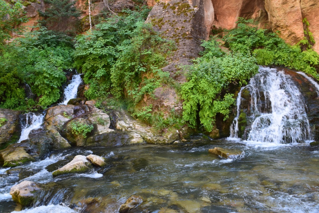
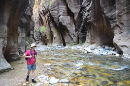
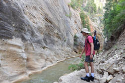
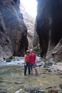 Taylor and I were lucky enough to win a permit to hike the Narrows in a lottery drawing the week before our hike. Permits can be reserved up to three months in advance, but we missed that since they sell out within hours of them opening. Our punctuality at Zion Adventure Company on the morning of our hike was made possible by a wonderful night of sleep at the Two Cranes Inn. Once we loaded our gear on to the transport bus, we joined eight more hikers for a ride up to Chamberlain’s Ranch.  We started on the trail at eight thirty in the morning and were in for a day full of spectacular sights. Roaring waterfalls, massive log jams, and sandbanks flush with vegetation were framed by massive vertical walls of red rock all along the 16 mile hike. Elevated gardens of grasses and shrubs grew on the steep rock walls as if they were fleeing the river’s cool touch. The Virgin River was crystal clear and littered with blue holes deep enough for a refreshing plunge. As we neared the Temple of Sinawava at the bottom of the Narrows, my body was worn from the day, but my mind was ever in awe. I was held most captive by the diversity of visitors who were splashing and smiling despite the unfamiliarity of those strangers among them, the heat of the day, and the happenings of the world outside of Zion National Park. It is difficult for me to think of a more beautiful sight or a more beautiful place to wander around for 12 hours with great company by your side.
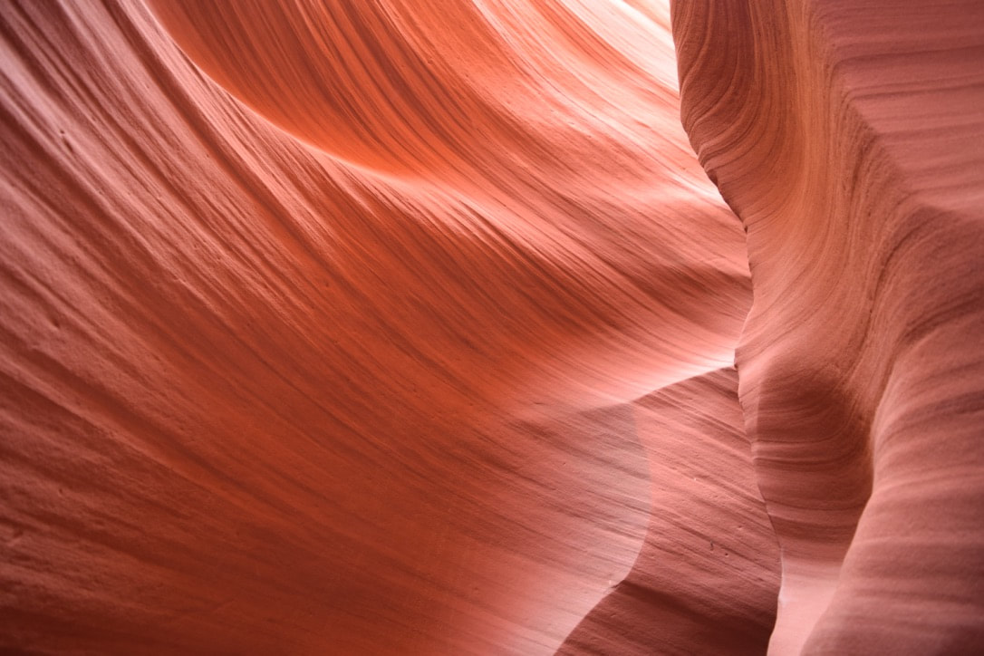
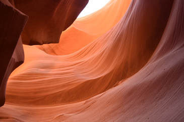
John and I made a quick stop at the picturesque Horseshoe Bend during our day in Page, Arizona. The short but hot walk was worth the view even if only for a few minutes. We stood in amazement at the size of the canyon and sheer degree of bend in the river. We were quite jealous of the kayakers and boaters on the Colorado River and decided that's how we want to enjoy the canyon on our next visit to Horseshoe Bend and The Grand Canyon. 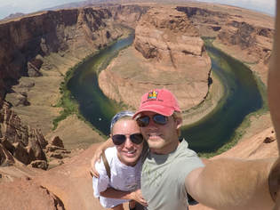 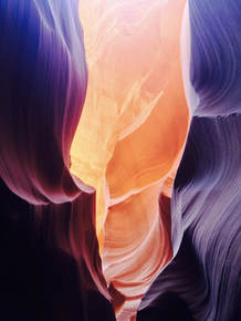 Antelope Canyon is one of the most picture perfect places in the world, and it tops every list of 'must see' places. We saw exactly why it has marveled visitors for years when we stood between the lower canyon's walls. You must be on a guided tour to legally enter the canyon. Tours are offered by a few companies in and around Page, Arizona. Just an hour before we arrived, we managed to grab the last spot on an early morning tour with Dixie Ellis Lower Antelope Canyon Tours. We were one of the last groups to tour the canyon for the day, because the tour companies must halt tours once the ground temperature reaches 105 degrees. 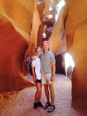 Our tour guide, Julie, was a native Navajo woman. Even though she was raised on the outskirts of the reservation and is self-admittedly more modern than traditional, she told us of lore and legends that surround the land and her people. She answered every question we had about her culture and was extremely familiar with the canyon. After all, she played in and around it as a child. After standing in line under large shop fans in the desert heat, we took a few flights of descending stairs and were surrounded by the sweeping, red canyon walls. Every turn of the canyon provided us with new forms and colors to marvel at. Julie added to the experience by taking several pictures for us and pointing out formations on the walls that looked like faces and animals. We took hundreds of postcard-worthy pictures and gained a new love for slot canyons.
 John and I’s wonderment in Zion National Park never ceased. from the curvy 28 mile long entrance drive to the final bus ride to our car, we loved every view the park had to offer. We knew that we wanted to hike The Narrows and Angel’s Landing, and we were glad to have done our research and planned ahead before arriving. We found that a permit and a reservation with a shuttle company were required to hike the Narrows from the top down, but no special permits were needed to hike Angel’s Landing. Our first attempt at passes wasn’t successful, as the online spots fill up as soon as they open three months before the hiking date. We applied for the online lottery that opens one week in advance of the hiking date, and to our surprise, we both won day-trip permits! We found out the good news two days before our hike and were lucky to get a spot on a shuttle ride with Zion Adventures the same day due to a cancellation 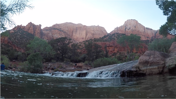 As soon as we arrived at the park on the Fourth of July, we picked up our narrows permits from the visitor’s center. We paid our dues, signed the waivers, and booked it out of there to find a good swimming hole. To get to a swimming hole or go anywhere else in Zion, we had to take the shuttle system. It runs frequently but does get backed up at the visitor’s center during the busy morning hours. The bus took us to the Canyon Junction stop, where we hopped into the Virgin River for a cool swim with a beautiful view. We skipped rocks and slid down the waterfall until we had worked up an appetite for a burger from The Zion Brewery. After a restful night at the Two Cranes Inn, we met our Zion Adventure shuttle bright and early just a few miles outside of the park entrance in Springdale. Our driver gave us a few pointers during the one and a half hour drive to Chamberlain’s Ranch. She dropped us off at the trailhead with a, “Good luck!” The narrows hiking trail winds through a diverse area for the first few miles before entering the actual Narrows. Once we were between the thousand-foot-high walls, I forgot what the rest of the world looked like. The sheer mass of the canyon is enough to humble anyone. After we waded, climbed, hiked, and swam through the Narrows for 16-miles, we were exhausted.
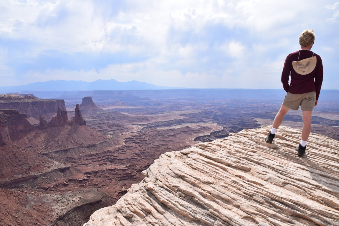
 We pitched our tent for the night at Zion River Resort and got a great night’s rest. It was such good rest that we didn’t get moving until almost 10 AM. Despite our slow start, we decided to enjoy breakfast at MeMe’s Café. The hearty breakfast was much needed before the monstrous Angel’s Landing hike. The exhilarating, strenuous, and blistering hot hike was worth every step to see an incredible view of Zion National Park. ‘Straight up land’--as the native people call it--is awe inspiring from the top of Angel’s Landing. It was the best way we could’ve ended our incredible journey through Zion National Park. We can’t wait to go back and find new ways to explore the canyon.
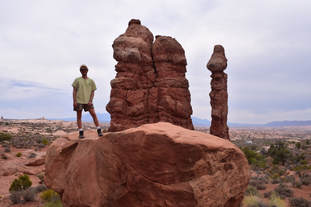
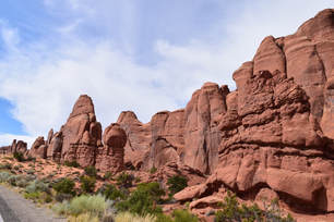
 Our day at Arches National Park began with a stop at the visitor’s center. The information lines were long, and the gift shop was stuffed full of patrons so we grabbed a map and drove into the park. Most of the park can be accessed from the main road that cuts straight through the middle of the park; the namesake formations can be reached after a short drive littered with scenic formations. We stopped along the road several times to get out and explore around the lesser known formations.
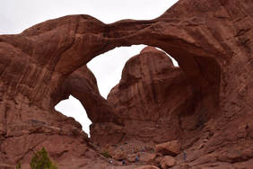
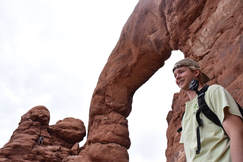
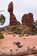 Balanced Rock is the first big name formation you pass when driving through the park and it is definitely the most fascinating formation along the roadway. Just beyond Balanced Rock lie a cluster of the park’s treasures: Double Arch, Turret Arch, and the North and South Windows are all neighbors with a shared parking lot. They are all very accessible by foot and well worth the time spent exploring, but we decided to keep our day moving and go check out the sand dune arch.
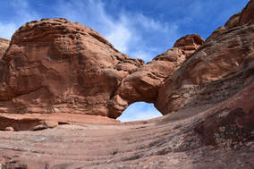
 We drove over to the Devils Garden area to sadly find out that part of the park was closed off for construction, but we were still able to explore around the Sand Dune Arch. We marched through the bright red sand and narrow canyon walls to find an opening with a great hidden surprise: a delicate arch with a giant slit in the middle. The formation looked as if two animals were frozen in a kiss for all of eternity, put on display for everyone to look at. As great as this formation was, nothing could compare to the main treasure of the park that we would hike to next. Delicate Arch is a creation of time that left me reeling in its presence. A steep one and one half mile hike is the price to be paid if you wish to see it up close and personal. I recommend it. The elevation gain of roughly 600 feet seemed to be grueling for some, but the expression of struggle vanished from their faces once the destination had been reached. The entire area of the park that we saw was stunning, but nothing compares to the wonder that is Delicate Arch. 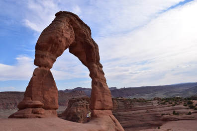  The best way to view Canyonlands National Park is via hot air balloon with Canyonlands Ballooning at sunrise. If you are on a tight budget or just aren’t a morning person, driving through the park and hiking around is just as beautiful. Canyonlands is split into three districts: The Needles, Island in the Sky, and The Maze. John and I started our driving tour from the Island in the Sky visitors center. As soon as we entered the park, we noticed a change in the environment; it became more desolate and windy the higher up we went. 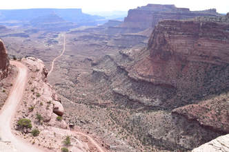 Our first pull off was at the Shafer Canyon Overlook. We climbed all over the rocks and gazed out over the land debating how the canyons might've formed while scrutinizing the modern scientific explanations. After those conversations ended, we hopped back in the car and headed to mesa arch. Mesa Arch is a smaller arch and had several families waiting for pictures, so we avoided the crowd and hiked off trail to the next peak over. We climbed up to the top to soak up the sun and spread out onto the white sandstone. Our thirst drove us from the peak, down onto the mesa arch trail, and out to the car. Our next stop was the Grand View Point Overlook. There isn’t much exploring to do at this stop, but the view is magnificient. It overlooks miles of desert, far away rock spires, and old uranium mining roads. Canyonlands is a park that we plan to come back to and spend more quality time in. There are lots of campsites in the park and plenty of trails in each of the three areas. We can’t wait to go back and experience more of Canyonlands National Park.
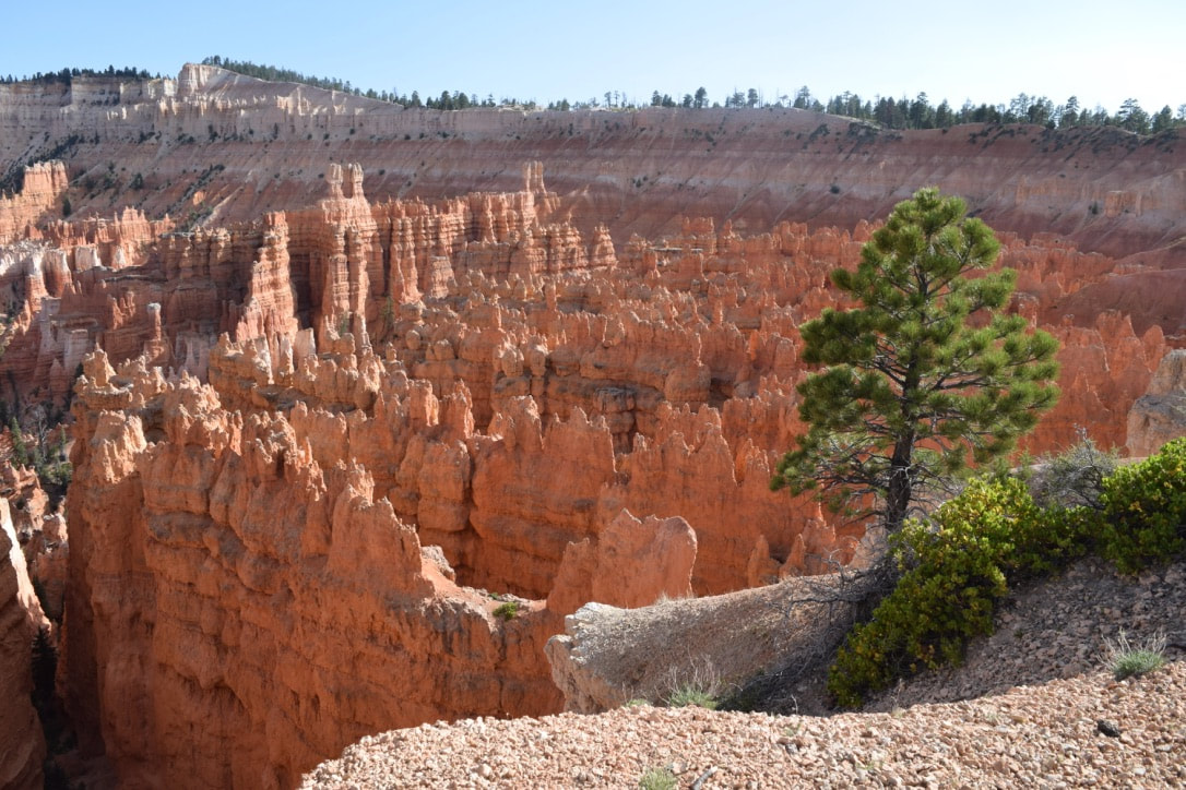
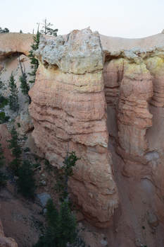
 A hearty meal from the Cowboy Buffet and Steak Room at Ruby’s Inn prepared Taylor and I for exploring Bryce Canyon’s scenic views and hiking into the canyon to camp for the night. The bus system that would ferry Taylor and I around the park was always punctual and rarely full. At any stop in the upper area of the park, a bus was guaranteed within fifteen minutes. Our first stop was the visitor’s center to acquire a camping permit for the night. They do not take online reservations for backcountry passes so we were going in blind hoping to get a site, and lucky for us we got the last one and it was at the site we wanted. Unbeknownst to us, we would also be acquiring a bear canister to pack all of our food; fortunately the extra container didn’t take up too much room once we filled it with our belongings. With our packs reorganized, we loaded a bus and set out to see Bryce Canyon. The most spectacular of the developed viewpoints is Inspiration Point. Looking out over the amphitheater of hoodoos from 8,100 feet was breathtaking. The complexity of each hoodoo in sight was enough to capture my attention for an entire evening, but we had to move on. Sunset and Sunrise Points were impressive as well, but all three would have been more impressive had we been able to afford the time to explore the hiking trails that descend into the canyon. 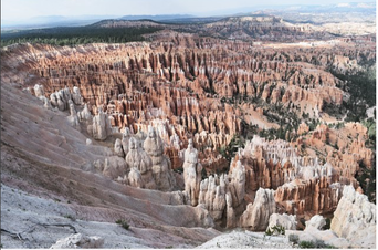 Inspiration Point
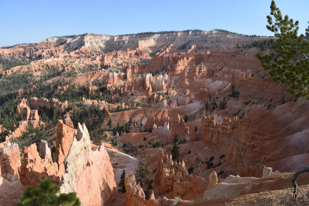
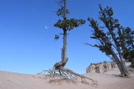
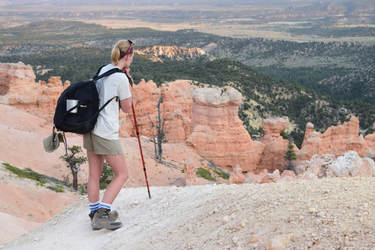 The last bus of the day dropped Taylor and I off at Bryce Point for our roughly three mile hike to our reserved campsite at Right Fork Yellow Creek. Along this hike, I discovered just how diverse Bryce Canyon is; from large pines surrounded by grasses and shrubs to hillsides of loose rock and massive boulders, there is something new to see around every corner. We passed the ‘Hat Shop’ at about two miles into our hike. This natural phenomena echoes Arches National Park’s ‘Balancing Rock’ in smaller and more frequent occurrences. The fifteen or so balanced ‘hats’ would be an unknown signal that we were approaching our campground. 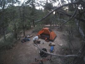 Situated next to a bubbling canyon stream, the clearing that is Right Fork Yellow Creek campground couldn’t have been a more welcome sight. We assembled our tent and deployed our Reehut Camp Stove with only a few minutes of sunlight left in the day. The ban on campfires in Bryce was off-putting initially, but I was sold on using a portable burner when Taylor began cooking less than ten minutes after we’d arrived at camp. The Under the Rim Trail continues on for approximately 19 more miles, but Taylor and I had a schedule to honor, and sadly had to meander our way back out of the canyon the next morning. We made a quick breakfast and closed down our campsite and got back on the trail. We made the climb back out of the canyon in the midday heat (big mistake) and praised the sight of a bus waiting as we reached the rim. All-in-all, Bryce Canyon was one of my favorite places along our Utah route, and I can only hope to go back and continue exploring the many trails that twist through those mystifying hoodoos.
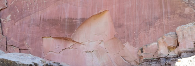 Petroglyphs right inside of the park. The missing piece of rock has been missing since the 1950s when it fell from natural causes. Petroglyphs right inside of the park. The missing piece of rock has been missing since the 1950s when it fell from natural causes. Capitol Reef was one of the more interesting parks we visited, and we wish we'd had more time to learn about the histories and mysteries of the area. Once we made it into the park, we stopped a few times to look at different formations and some ancient petroglyphs.
After arguing over the weird body shapes and head decorations depicted, we drove to the visitor’s center to get some answers and a map. Although we’ve come to no conclusion on the drawings, we were able to buy magnets with replica depictions. We drove through the historic town of Fruita, where fruit groves and an abandoned school are the main attractions. Panoramic point was our first stop for a short hike. We wanted to hike to Chimney Rock but kept on driving so that we could make it to Bryce Canyon National Park before sundown. Our visit to Capitol Reef was short, but we are glad to have seen some of the major points of interest. We will definitely be back one day to do more hiking and petroglyph deciphering. |
Talkin' 'bout Tacos:
I'm Taylor, aka Tacos! I am sharing my journeys and experiences from across the world hoping to inspire travel and adventure in all who read. Archives
June 2024
|